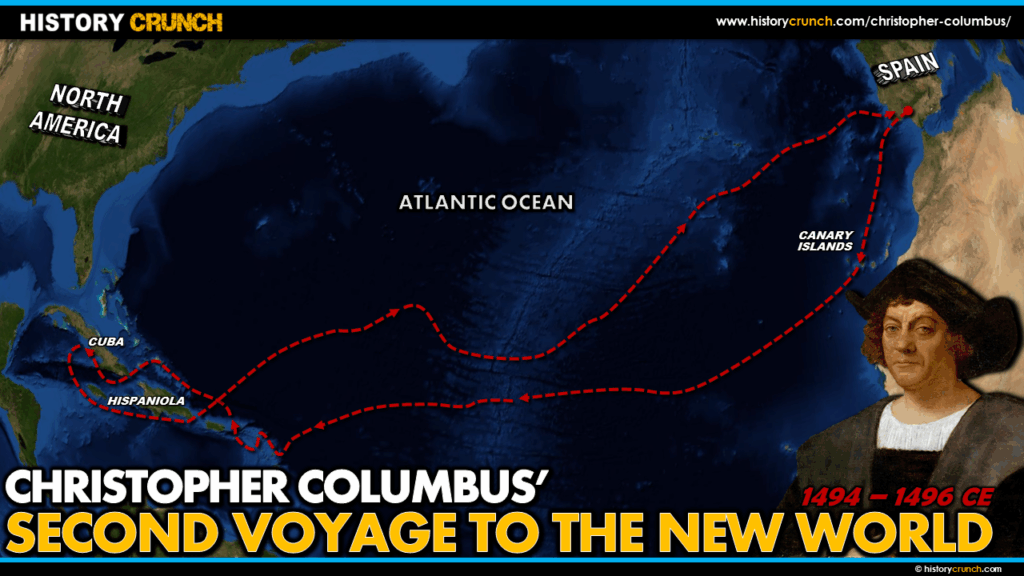
Christopher Columbus’s second voyage to the New World began on September 24th, 1493 and was far larger in scale than his first. Rather than three ships and a small crew, Columbus set out with 17 ships and approximately 1,200 people including priests, farmers, soldiers and settlers. The second voyage had a clear colonial mission: to establish permanent settlements in the New World. It also marked the beginning of the Columbian Exchange, as Columbus brought with him seeds, plants and livestock that had never existed in the Americas before. This map was created by History Crunch to help students visualize the geographic route of Columbus’s second voyage and is based on the History Crunch article titled Christopher Columbus Second Voyage.
Christopher Columbus Second Voyage to the New World Map
About This Map
This map of Christopher Columbus’s second voyage to the New World was created by the History Crunch team to help students and teachers understand the geographic route and significance of his second and most consequential voyage. It is designed as a visual learning tool to accompany our full article on Christopher Columbus’s second voyage. Teachers may use it as a classroom display, a geography activity, or a discussion starter about the beginning of European colonization and the Columbian Exchange.
What This Map Shows
The map traces the complete route of Columbus’s second voyage from Spain to the Caribbean and through the many islands he explored before returning to Hispaniola. As with his first voyage, Columbus first sailed south from Spain to the Canary Islands, departing from there on October 13th, 1493. However on this voyage he took a more southerly route across the Atlantic than he had on his first, arriving in the southeastern section of the Caribbean in early November of 1493.
The map shows Columbus’s arrival in the Lesser Antilles, a string of smaller islands in the southeastern Caribbean that he had not explored on his first voyage. On November 3rd, 1493 Columbus spotted an island he named Dominica. He then traveled westward along the island chain, making landfall on and naming many of the islands that are still known by those names today including Antigua, Montserrat, Nevis, Saint Kitts, Saint Martin and the Virgin Islands. At Saint Croix his men came into conflict with an indigenous group, the first recorded violent conflict between Europeans and Caribbean peoples on this voyage.
The map highlights Columbus’s arrival at the island he named San Juan Bautista, known today as Puerto Rico, and his subsequent journey to the larger island of Hispaniola where he had left nearly 40 settlers to establish the settlement of La Navidad on his first voyage. Arriving at Hispaniola on November 22nd, 1493, Columbus was shocked to find La Navidad completely destroyed and the settlers killed by the Taino indigenous people who lived there. He abandoned the site and sailed further along the northern coast of Hispaniola where he established a new settlement called La Isabela in the modern-day Dominican Republic.
The map also shows Columbus’s further explorations during the second voyage, including his departure from La Isabela on April 24th, 1494 to explore westward in the continuing belief that he had reached the shores of Asia. He arrived at Cuba on April 30th and explored the island of Jamaica days later before returning to Hispaniola. Throughout this period the settlement of La Isabela struggled badly. It was struck by hurricanes in both 1494 and 1495, the settlers failed to find gold, and the relationship with the Taino people deteriorated as Columbus and the settlers began capturing and enslaving them. Columbus eventually departed for Spain on March 10th, 1496, arriving home on June 11th of that year.
How to Use This Map in the Classroom
This map works well as a visual companion to the second voyage article and pairs naturally with the first voyage map to help students compare the two journeys in terms of scale, route and purpose. It can be used as a geography activity asking students to identify the islands Columbus visited and named during his journey through the Lesser Antilles and to locate Hispaniola and the sites of La Navidad and La Isabela. Teachers may also use it as a discussion prompt asking students to consider the consequences of European colonization for the Taino people, noting that the Taino population on Hispaniola declined by as much as two-thirds within just four years of Columbus’s arrival on his first voyage.
Related Articles
To learn more about the topics covered in this map, visit the following History Crunch articles:
- Christopher Columbus Second Voyage
- Christopher Columbus First Voyage
- Christopher Columbus Third Voyage
- Christopher Columbus
- Columbian Exchange
- Age of Exploration Overview
- Impacts of the Age of Exploration
- Should Christopher Columbus Be Celebrated?