Maps

Silk Road Map

Silk Road Map

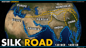
This Silk Road map was created by History Crunch to help students and teachers understand the geographic routes of one of the most important trade networks in human history. It shows the land and sea routes that connected China and East Asia to the Mediterranean and Europe from approximately 120 BCE to 1450 CE. Designed for students in grades 5 to 12.

Later Crusades Map

Later Crusades Map

This Later Crusades map was created by History Crunch to help students and teachers understand the geographic routes of the Sixth, Seventh, Eighth and Ninth Crusades between 1228 and 1272 CE. It shows the key destinations of each campaign including Jerusalem, Egypt, Tunis and the port city of Acre, and illustrates how the crusading movement gradually weakened over time. Designed for students in grades 5 to 12.

Fifth Crusade Map

Fifth Crusade Map

This Fifth Crusade map was created by History Crunch to help students and teachers understand the geographic route of the Fifth Crusade between 1217 and 1221 CE. It shows the path taken by European crusaders from Europe across the Mediterranean to Egypt, including the key locations of Damietta and the Nile Delta region. Designed for students in grades 5 to 12.

Fourth Crusade Map

Fourth Crusade Map

This Fourth Crusade map was created by History Crunch to help students and teachers understand the geographic route of the Fourth Crusade between 1202 and 1204 CE. Unlike the previous crusades, the Fourth Crusade never reached the Holy Land and instead ended with the shocking sack of Constantinople, the capital of the Byzantine Empire. Designed for students in grades 5 to 12.

Third Crusade Map

Third Crusade Map

This Third Crusade map was created by History Crunch to help students and teachers understand the geographic route of the Third Crusade from Europe to the Holy Land between 1189 and 1192 CE. It shows the paths taken by the armies of Richard I of England, Philip II of France and Frederick Barbarossa of Germany as they traveled toward the Middle East. Designed for students in grades 5 to 12.

Second Crusade Map

Second Crusade Map

This Second Crusade map was created by History Crunch to help students and teachers understand the geographic route of the Second Crusade from Europe to the Holy Land between 1147 and 1149 CE. It shows the paths taken by the French and German armies as they traveled toward the Middle East and the key locations involved in this ultimately unsuccessful campaign. Designed for students in grades 5 to 12.

First Crusade Map

First Crusade Map

This First Crusade map was created by History Crunch to help students and teachers understand the geographic route of the First Crusade from Europe to the Holy Land between 1096 and 1099 CE. It shows the path taken by European crusaders from their homelands through Constantinople and into the Middle East, including the key locations captured along the way. Designed for students in grades 5 to 12.